Update: Tropical Storm Arthur forms off Florida's coast
Update: 11:38 a.m.
The first tropical storm of the 2014 Atlantic Hurricane Season has formed, according to the National Hurricane Center.
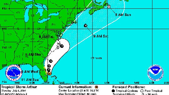
Arthur is heading northwest at 2 mph about 95 miles southeast of Cape Canaveral, according to the NHC's 11 a.m. advisory.
The storm has winds of 35 mph and is expected to strengthen during the next 48 hours.
A tropical storm watch has been issued for the coast of east-central Florida, from Fort Pierce northward to just south of Flagler Beach.
Arthur will take more northern turn by Wednesday when it's expected to pass east of northeastern Florida. The storm is on track to near the Carolinas by Thursday night.
According to the forecast track from the National Hurricane Center, the storm will near the North Carolina outer banks around 2 a.m. Friday as a hurricane.
"Heavy rains of 2 - 4" will likely affect the Northwest Bahamas and eastern coast of Florida Tuesday through Wednesday," says Jeff Masters of Weather Underground.
Southwest Florida will see drier weather Tuesday through Friday with isolated showers in the forecast. Temperatures will remain in the 90s with some gusty winds on Wednesday.
Update: 8:10 a.m.
An area of low pressure off of the Florida east coast has developed into the first tropical depression of the 2014 Atlantic Hurricane Season.
The system is located about 105 miles east southeast of Cape Canaveral, Fla., as it moves southwestward.
A tropical storm watch has been issued for the coast of east-central Florida, from Fort Pierce northward to just south of Flagler Beach.
Strengthening is expected during the next 48 hours and the system could become Tropical Storm Arthur on Tuesday.
The system is expected to turn westward Tuesday night and northward by Wednesday near the Florida east coast.
A turn toward the northeast near the southeastern coast of the United States is expected by Thursday.
Models tracking this system generally agree on a south to south-southwest movement over the next 24 hours, then turning back toward the north-northwest and paralleling the Florida coastline through Wednesday night.
